|
 |
|
Three generations of film-makers have based movies on the Bounty story. The Tahitian woman, Tarita Teriipaia, co-starred with Marlon Brando in the1962 MGM film “Mutiny on the Bounty".
|
the
story
of
the
Bounty
mutiny
is
too
well
known
to
repeat
here;
the
prior
incidents,
the
seizure
of
the
ship,
and
the
subsequent
occurrences
have
been
the
subject
of
numerous
books,
articles,
and
five
movies
(one
an
Oscar
winner).
Following
the
mutiny
and
after
almost
3,618
miles
of
incredible
hardship
Captain
William
Bligh
and
his
supporters
arrived
at
Timor
in
the
East
Indies,
having
sailed
in
the
Bounty's
open
longboat.
Mystery
has
surrounded
the
Bounty's
movements
on
her
final
voyage.
Christian
and
his
followers
departed
from
Tahiti
for
the
last
time
on
22
September
1789
but
they
failed
to
reach
their
haven
of
Pitcairn
Island
until
15
January
1790.
Why
did
a
direct
crossing
of
only
1200
miles
take
four
months?
At
the
most
this
short
voyage
should
have
taken
less
than
two
weeks.
The
object
of
the
present
article
is
to
review
the
events
on
the
Bounty
during
the
eight
months
from
the
time
of
the
mutiny,
to
the
founding
of
the
settlement
at
Pitcairn.
In
particular
an
explanation
is
offered
for
the
previously
unaccounted
for
four
months
of
voyaging.
|

|
|
Left - William Bligh, 1754-1817, engraving by J. Chapman, published October
1802.- Courtesy National Library of Australia. [nla. pic-an [9454404].
Centre: John Adams, 1764-1829, engraving by Charles Beyer,
Paris, circa 1830. Adams was the last survivor of the mutineers when the
Topaz visited Pitcairn in 1808. [Courtesy National Library
of Australia.] Adams sold Kendall's H2 marine timekeeper to Folger
of the Topaz; this had been been issued to Bligh. (The watch is illustrated
below left.) The fate of Hawkesworth's volumes of Cook's voyages which
Adams also held has not been recorded. (Courtesy National Library of
Australia. [nla.pic-an9281376]
Right - After an engraving by H. Adlard of Thursday October Christian,
Fletcher Christian's son. From Rev. T. Murray, Pitcairn, the Island,
the People and the Pastor, ... London, 1885.
|
The
sole
survivor
of
the
mutineers,
John
Adams
(centre
above)
recounted
his
story
to
Captain
F.
W.
Beechey
during
the
visit
of
HMS
Blossom
to
Pitcairn,
in
December
1825.
Adams
declared
that
they
made
for
Pitcairn
from
Tahiti
in
September
1789,
but
he
also
said
“the
Marquesas
Islands
were
first
mentioned.”
This
ambiguous
statement
is
not
made
any
easier
to
understand
when
it
is
considered
that
he
told
Captain
Mayhew
Folger
of
the
American
ship
Topaz,
of
Boston,
they
“went
in
search
of
a
group
of
islands,
which
[they
saw]
on
the
chart
placed
under
the
head
of
Spanish
discoveries.
They
crossed
the
situation
of
these
imaginary
isles,
and
satisfied
themselves
that
none
existed.”
|

|
|
Courtesy National Library of Australia.
(an6308155 U3432 NK267).
|
|
The mutineers turning Lieut. Bligh and part of the officers and crew
adrift from His Majesty's ship the Bounty .Aquatint etching,
hand coloured, after Robert Dodd's (1748-1816) famous
painting of Fletcher Christian aboard HMS Bounty bidding farewell to
Captain William Bligh and eighteen loyal members of his crew.
|
Clues
revealing
some
details
of
the
Bounty’s
last
voyage
came
to
light
only
after
Folger
discovered
the
settlement
at
Pitcairn
in
1808.
Neither
Christian
nor
any
of
the
other
sailors
kept
a
journal
on
the
Bounty
after
they
seized
the
ship.
A
number
of
narratives
written
mostly
by
visitors
to
Pitcairn
after
1808,
provide
some
information
concerning
the
last
voyage,
but
a
considerable
part
of
the
scant
evidence
is
contained
in
accounts
dictated
in
1817/1818
and
1821,
by
Jenny,
the
Tahitian
wife
of
Isaac
Martin,
a
former
able
seaman
on
the
Bounty.
Books,
charts,
and
navigational
aids
on
the
Bounty
|

|
|
Courtesy New York Public Library. [1258749 - 611111] |
|
Detail from the 1775 edition of Green's chart:
"A chart of North and South America: including
the Atlantic and Pacific Oceans, with the nearest
coasts of Europe, Africa and Asia", published
1775, By John Green, fl. 1730-1753, engraved
by Thomas Jefferys.1 map on 3 sheets
: hand col. 42 x 110 cm. or smaller.
Notes accompanying map in the NYPL.
Note 1. Prime meridian: London and Ferro.
Reference: Stevens & Tree.
Comparative cartography. |
A
review
of
the
Bounty's
final
voyage
is
given
under
sub-headings
that
follow
but
in
this
section
it
is
necessary
to
mention
some
of
the
books,
charts,
and
navigational
instruments
carried
on
the
ship.
Full
details
of
the
printed
material
are
unknown
but
Captain
Bligh
later
claimed
that
Christian
prevented
him
“on
pain
of
death”
from
taking
any
charts
off
the
ship.
Another
early
visitor
to
Pitcairn,
John
Shillibeer,
mentions
in
his
narrative
“several
books
belonging
to
Bligh
which
were
taken
out
of
the
Bounty.”
He
describes
the
volumes
of
Hawkesworth's
account
of
Cook’s
first
voyage
but
not
the
volumes
of
Cook's
second
and
third
voyages
which
were
certainly
Christian’s
main
source
for
details
of
Tubuai,
the
“Spanish
Isles,”
and
the
Marquesas
Islands.
If
the
expedition
carried
the
first
edition
of
the
narrative
of
Cook's
third
voyage,
published
at
London
in
1784,
Roberts’
General
Chart
[of
the
world]
was
no
doubt
studied
by
Christian.
In
some
later
editions
this
chart
is
included
in
a
separate
atlas
of
plates.
Since
Bligh’s
voyage
took
place
before
the
founding
of
the
British
Hydrographic
Office
in
1795,
the
Admiralty
relied
to
a
large
degree
on
commercial
charts.
Almost
certainly
Bligh
was
provided
with
Green’s
chart
of
the
South
Pacific,
first
published
in
1753
by
the
London
chart-publisher
Thomas
Jefferys,
reissued
with
major
changes
in
1775,
and
reprinted
in
1775
and
1783.
Of
particular
interest
in
both
Roberts’
and
Green’s
chart,
is
the
depiction
of
Spanish
discoveries
and
supposed
sightings
of
islands
in
the
Pacific.
Green’s
chart
portrays
the
Solomon
Islands
and
the
Marquesas
Islands,
but
the
Solomons
are
grossly
misplaced.
Roberts’
chart
ignores
the
Solomons
but
portrays
Mendaña’s
and
Cook’s
discoveries
in
the
Marquesas
group.
South-east
of
the
islands
now
known
as
the
Tuamotu
Archipelago,
Roberts’
chart
includes
a
legend
reading,
“Isles
said
to
be
discd.
by
the
Spaniards
1773.”
As
well
as
being
provided
with
the
usual
sextants
and
compasses,
the
Bounty
carried
at
the
insistence
of
Sir
Joseph
Banks,
a
marine
timekeeper
made
by
Larcum
Kendall.
(Kendall's
K2
watch).
Thus,
Bligh,
and
later
Christian,
were
well
equipped
for
fixing
a
position
at
sea.
“Huzza
for
O
Taheite!”
|
 |
|
Click
image
to
enlarge.
|
William
Bligh
and
eighteen
men
were
cast
adrift
in
the
Bounty’s
twenty-three
foot
launch,
ten
leagues
south-west
of
Tofua,
one
of
the
western
Tonga
Islands,
to
the
sound
of
“down
with
Captain
Bligh!
huzza
for
O
Taheite!”
from
the
mutineers.
Bligh’s
log
ends
abruptly
the
previous
day,
Monday
27
April
1789.
Fletcher
Christian,
master’s
mate,
took
charge
of
the
ship
and
after
listening
to
the
views
of
the
twenty-five
men
remaining
on
the
Bounty,
decided
to
make
for
Tubuai
in
the
Austral
Islands.
|
|
|
Courtesy State Library of
New South Wales.[a928973r]. |
|
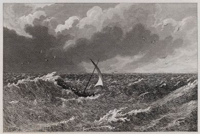
An etching by Robert Batty (1789 -1848)
circa 1831-
Following
the
mutiny
and
after
almost
3,618
miles
of
incredible
hardship
Captain
William
Bligh
and
his
supporters
arrived
at
Timor
in
the
East
Indies,
having
sailed
in
the
Bounty's
open
longboat.
|
|

|
|
Courtesy National Library of Australia. [an648981-NK 2646.] |
|
Robert Cleveley (1747-1809).
"The attempt by Capt. Bligh of the Bounty who with 18 sailors had been set adrift in an open boat on April 28th, 1789, to land on Tofoa".
Watercolour. |
Christian’s
plan
was
to
investigate
Tubuai
and
then
sail
north
to
Tahiti
for
provisions.
Tubuai
seemed
suitably
remote
and
the
ideal
island
to
select
for
a
retreat.
To
deceive
Bligh,
the
ship
stood
some
time
to
the
north-north-west
but
was
afterwards
put
about
and
her
course
directed
eastward.
| |
 |
Huzza for Tahiti ! |
Christian
took
over
Bligh’s
cabin
and
library,
consulted
the
narrative
of
Cook’s
third
voyage,
and
noted
that
Cook
discovered
Tubuai
in
latitude
24 degrees
south,
on
8
August
1777.
Bligh
had
served
as
master
on
HMS
Resolution
at
the
time
of
the
discovery
but
whether
he
mentioned
details
of
earlier
explorations
in
conversations
with
Christian
is
unknown.
In
any
case
Cook
had
not
landed
on
Tubuai.
It
is
sometimes
claimed
that
Christian
discovered
Rarotonga
which
is
close
to
a
direct
course
from
Tofua
to
Tubuai,
during
the
month-long
voyage
to
Tubuai.
It
is
possible
but
the
evidence
in
support
of
this
discovery
is
not
strong.
A
short-lived
settlement
at
Tubuai
The
Bounty
arrived
off
Tubuai
on
24
May
1789,
and
the
following
day
Christian
with
some
difficulty,
anchored
the
ship
inside
the
lagoon.
The
inhabitants
immediately
made
it
known
that
new
immigrants
were
not
welcome,
and
seeing
the
small
number
of
crew,
they
attempted
to
seize
the
ship.
Christian’s
visits
ashore
where
he
noticed
coconut,
breadfruit,
banana
trees
and
taro,
convinced
him
of
the
suitability
of
the
island
for
the
proposed
settlement
and
he
believed
a
little
time
would
conciliate
the
local
people.
He
therefore
proposed
to
press
on
to
Tahiti
and
return
after
procuring
pigs,
goats,
chickens,
and
some
women
as
companions
for
the
men.
Thirty-six
years
later
it
was
the
need
for
female
companions
that
Adams
remembered
as
the
main
reason
for
returning
to
Tahiti.
Sailing
from
Tubuai
on
30
May,
the
Bounty
reached
Tahiti
and
anchored
in
Matavai
Bay
on
7
June.
By
16
June
Christian
had
obtained
a
large
number
of
pigs,
goats,
chickens,
a
bull
and
a
cow,
and
even
a
few
cats
and
dogs.
The
ship
sailed
a
few
days
later,
but
with
only
nine
Europeans
and
about
thirty-four
Tahitians
including
partners
for
a
few
of
the
men.
Sixteen
mutineers
decided
to
stay
at
Tahiti.
On
the
second
visit
to
Tubuai,
the
Bounty
reached
the
island
on
26
June.
With
the
Tahitians
acting
as
interpreters,
friendly
relations
were
soon
established
between
the
new
arrivals
and
the
local
population.
However,
trouble
gradually
developed
and
it
was
not
long
before
the
mutineers
realized
that
only
on
an
island
without
inhabitants
could
they
safely
make
their
new
home.
Reluctantly,
Christian
decided
to
withdraw.
The
Bounty
set
sail
for
the
second
time
from
Tubuai
on
15
September
bound
for
Tahiti
to
begin
another
four
months
of
wandering
in
the
south
seas.
Christian's
aim
was
to
find
an
island
not
only
uninhabited
but
also
unvisited
and
without
a
harbour.
Eastward
in
search
of
a
home
On
returning
again
to
Tahiti,
Christian
made
it
clear
that
the
ship’s
stay
was
only
for
one
day.
And
he
knew
it
was
important
to
find
consorts
for
all
the
intending
settlers.
On
the
night
of
21
September,
women
were
invited
on
board
and
taken
below
to
supper
and
bed,
having
been
told
that
the
Bounty
would
be
moving
to
another
anchorage
in
the
morning.
But
soon
the
anchor
cables
were
quietly
cut
and
the
Bounty
got
under
way.
The
ship
later
in
the
morning
passed
close
to
the
atoll
of
Tetiaroa,
twenty-six
miles
north
of
Tahiti.
Near
Moore
a
a
number
of
women
went
ashore
in
a
canoe
which
came
out.
These
final
withdrawals
reduced
the
Bounty’s
complement
to
nine
Europeans
and
nineteen
Tahitians.
Then,
as
the
Bounty’s
sails
dropped
over
the
horizon
they
vanished
as
far
as
the
outside
world
was
concerned.
|

|
|
Map
above
-
detail
from
Roberts'
General
Chart,
published
in
1784,
showing
parts
of
Polynesia.
Christian
consulted
this
chart
before
investigating
both
the
"Spanish
Isles"
area
in
the
south-east
Pacific
,
and
the
Marquesas
Islands.
The
tracks
shown
relate
to
Cook's
three
voyages.
The
detail
below
is
an
enlargement
of
the
area
referring
to
the
"Spanish
Isles".
Tahiti
is
in
the
group
of
islands
top-left. |
|
Author's
collection. |
An
attempt
at
unravelling
the
puzzle
of
the
drawn-out
passage
was
made
in
1958
by
H.
E.
Maude
in
a
study
published
in
the
Journal
of
the
Polynesian
Society.
Maude
believed
that
Christian
headed
for
the
Tonga
area,
not
far
from
the
scene
of
the
mutiny,
then
on
to
the
southern
Lau
Group
of
the
Fiji
Islands,
before
heading
for
Pitcairn.
This
idea
is
based
on
one
of
Jenny’s
accounts
given
to
a
missionary
at
Tahiti,
thirty-two
years
after
the
event.
However,
Maude’s
unrealistic
theory
fails
to
take
into
account
the
evidence
relating
to
“the
Spanish
Isles”
and
the
object
of
the
cruise
which
was
to
search
for
a
remote,
unvisited,
and
unpopulated
island
for
the
new
home.
The
available
evidence
is
strewn
with
red
herrings
and
blurred
recollections
but
a
few
facts
stand
out.
Taking
into
consideration
Adams;
remarks,
"the
Marquesas
Islands
were
first
mentioned,
and
"they
went
in
search
of
Spanish
discoveries,"
it
makes
more
sense
to
believe
that
Christian
headed
south-east
from
Tahiti
and
away
from
the
scene
of
the
mutiny
in
September
not
west
as
Jenny's
account
explains.
The
link
between
Adams'
remarks
and
the
"Spanish
Isles"
legend
in
Roberts'
chart
in
the
area
of
latitude
32
degrees
south,
longitude
128
degrees
west,
is
apparent.
The
south-east
suggestion
also
ties
in
with
Adams'
remark
"they
crossed
the
situation
of
those
imaginary
isles
and
satisfied
themselves
that
none
existed".
|
 |
|
Map detail - see the note
accompanying the map, above. |
If
Christian
found
no
sign
of
the
“Spanish
Isles’’
after
searching
perhaps
for
a
week
or
two
he
headed
north.
In
Green’s
chart
the
Marquesas
Islands
are
placed
too
far
east
but
in
Roberts’
chart
their
position
is
fairly
correct.
A
remark
made
by
Jenny
that
provides
a
positive
clue
is
her
reference
to
passing
“between
two
mountainous
islands,
but
the
wind
was
so
strong
they
could
not
land.”
Maude’s
suggestion
that
the
islands
were
Hunga
Haápai
(400 ft)
and
Hunga
Tonga
(490
ft),
about
thirty
miles
north
of
Tongatapu
does
not
equate
with
Jenny’s
description.
There
are
few
mountainous
islands
in
the
south
Pacific
but
two
that
fit
the
account
are
Hiva
Oa
(3,904
ft),
and
Tahuata
(3,250
ft),
in
the
southern
group
of
the
Marquesas
Islands.
Christian
knew
from
reading
Cook’s
account
of
his
second
voyage
that
the
Resolution
passed
between
these
two
islands
(Haava
Strait)
before
anchoring
in
Mendaña’s
port
of
“Madre
de
Dios”
(Hapatoni
Bay),
at
Tahuata,
in
April
1774.
William
Hodges’
sketch
of
the
port,
reproduced
as
an
engraving
in
the
narrative
of
Cook’s
second
voyage,
must
have
tempted
Christian
to
visit
to
obtain
water
and
to
obtain
water
and
supplies.
However,
Jenny’s
statement
indicates
that
the
Bounty
did
not
anchor
at
the
Marquesas
Islands.
Probably
the
sight
of
large
numbers
of
local
inhabitants
as
well
as
the
strong
winds
discouraged
the
haven
seekers
from
further
investigations.
|
 |
|
Chart
of
Pitcairn
Island
(Plate
9)
bound
in
with,
John
Hawkesworth,
An
account
of
the
voyages
undertaken
Byron
...
Wallis
...
Carteret,
and
Cook...
London,
1773.
|
|
Author's collection. |
Adams
confirmed
in
his
statement
to
Beechey
that
Christian
consulted
Hawkesworth's
account
of
Carteret's
discovery
of
Pitcairn.
The
text
in
this
book,
partly
repeated
below,
includes
a
typographical
error
in
the
latitude
figure
and
a
serious
miscalculation
in
the
longitude
reckoning.
Christian
found
the
book
and
the
1785
chart
in
Bligh's
cabin
on
the
Bounty.
Christian
heads
for
Carteret’s
discovery
Perhaps
at
this
point,
after
abandoning
the
decision
was
made
to
head
for
Pitcairn;
but
if
water
and
supplies
became
scarce
during
the
voyage
south
it
was
important
to
find
an
island
to
replenish
the
casks
and
obtain
fresh
provisions.
Jenny
mentions
an
island
named
“Purutea”
where
they
obtained
supplies
at
one
point
during
the
extended
voyage.
An
island
near
the
southernmost
edge
of
the
Tuamotu
Archipelago
named
in
modern
charts,
Marutea,
is
the
likely
“Purutea.”
Since
Bligh’s
voyage
took
place
before
the
founding
of
the
British
Hydrographic
Office
in
1795,
the
Admiralty
relied
to
a
large
degree
on
commercial
charts.
Almost
certainly
Bligh
was
provided
with
Green’s
chart
of
the
South
Pacific,
first
published
in
1753
by
the
London
chart-publisher
Thomas
Jefferys,
reissued
with
major
changes
in
1775,
and
reprinted
in
1775
and
1783.
(See
detail
above.)
|
 |
|
Courtesy National Library of Australia.
[nla.pic-vn310379] |
|
"Interieur de Pitcairn" an engraving
by Charles Beyer, published at Paris circa 1830.This was Adams' house. The subject matter is similar to a sketch done in by F.W. Beechey of HMS Blossom when he visited the island in 1825. Beechey's sketch is also held in the National Library of Australia.
|
Of
particular
interest
in
both
Roberts’
and
Green’s
chart,
is
the
depiction
of
Spanish
discoveries
and
supposed
sightings
of
islands
in
the
Pacific.
Green’s
chart
portrays
the
Solomon
Islands
and
the
Marquesas
Islands,
but
the
Solomons
are
grossly
misplaced.
Roberts’
chart
ignores
the
Solomons
but
portrays
Mendaña’s
and
Cook’s
discoveries
in
the
Marquesas
group.
South-east
of
the
islands
now
known
as
the
Tuamotu
Archipelago,
Roberts’
chart
includes
a
legend
reading,
“Isles
said
to
be
discd.
by
the
Spaniards
1773.”
As
well
as
being
provided
with
the
usual
sextants
and
compasses,
the
Bounty
carried
at
the
insistence
of
Sir
Joseph
Banks,
a
marine
timekeeper
made
by
Larcum
Kendall.
(Kendall's
K2
watch).
Thus,
Bligh,
and
later
Christian,
were
well
equipped
for
fixing
a
position
at
sea.
Jenny
mentions
an
island
named
"Purutea.
An
island
near
the
southernmost
edge
of
the
Tuamotu
Archipelago
named
in
modern
charts,
Marutea,
is
the
likely
“Purutea.”
Christian
no
doubt
checked
the
accompanying
map,
and
also
Roberts’
chart,
both
of
which
provide
the
more
or
less
correct
latitude
figure
of
25º
02’
south.
|
... The evening of Thursday, the 2nd of July [1767], we discovered land to the northward ... upon approaching it the next day, it appeared like a great rock rising out of the sea: it was not more than five miles in circumference, and seemed to be uninhabited; it was however, covered with trees, and we saw a small stream ... I would have landed upon it, but the surf, which at this season broke upon it with great violence, rendered it impossible. ... We saw a great number of sea-birds hovering, ... and the sea here seemed to have fish. It lies in lat. 20o 2’ south: long. 133º 21’ west. It is so high that we saw it at the distance of more than fifteen leagues, we called it PITCAIRN’S ISLAND. |
Since
Christian
realised
that
an
approach
from
the
east
simply
required
him
to
find
the
twenty-fifth
parallel
and
steer
west
along
this
line
until
he
sighted
the
island,
he
most
likely
ignored
the
longitude
issue
to
a
large
degree.
However,
this
explanation
is
not
to
say
Christian
found
the
island
without
difficulty
or
indeed
from
the
east.
He
was
aware
of
Cook’s
failure
in
his
search
for
Pitcairn
in
July
1773.
|
 |
|
©National Maritime
Museum,
London. [A5510].) |
|
Larcum Kendall's K2watch made for the Board of
Longitude in 1771, and
issued to Bligh. The
mutineers kept the watch
and when the Topaz arrived
at Pitcairn in1808,Adams
sold the watch to Folger.
|
The
fact
that
Carteret’s
position
for
Pitcairn
is
200
miles
west
of
the
true
location
added
a
confusing
ingredient
to
Christian's
problem.
Carteret
sailed
before
the
chronometer
was
developed
in
1767
and
although
Kendall's
marine
timekeeper
was
giving
Christian
accurate
longitude
reckonings
he
could
only
guess
at
the
extent
of
Carteret's
errors.
Jenny
says
Christian
almost
gave
up
the
search
to
return
to
Tahiti.
This
remark
suggests
that
the
Bounty
reached
the
twenty-fifth
parallel
from
the
north,
but
west
of
Pitcairn,
and
Christian
steered
west,
in
which
case
he
might
have
sailed
for
some
days
before
deciding
to
turn
about
and
continue
the
search
by
heading
east.
Finally,
during
the
evening
of
15
January
1790,
Pitcairn
was
sighted
but
it
was
three
days
later
before
the
intending
settlers
could
attempt
a
landing
in the rough seas.
They off-loaded
everything
and
the
Bounty was
destroyed eight days
later,
on
23
January.
□
Bibliography
Beechey,
F.W.
Narrative
of
a
voyage
to
the
Pacific
...
2
vols
(London:
Colburn
&
Bentley,
1831;
Reprint
ed.
Amsterdam:
N.
Israel,
1968).
Cook,
James
A
voyage
towards
the
South
Pole
...
2
vols
(London:
Strahan
&
Cadell,1777.
Cook,
James
and
James
King
A
voyage
to
the
Pacific
Ocean
...
3
vols
and
folio
of
plates
(London:
Strahan
&
Cadell,
1784).
Hawkesworth,
John,
ed.,
An
account
of
the
voyages
undertaken
...3
vols
(London:
Strahan
&
Cadell,
1773).
Howse,
Derek,
Greenwich
time
and
the
longitude
(London:
National
Maritime
Museum
in
Association
with
A.T.
Kearny,
1998).
Jenny
(or
Teehuteatuaonoa)
First
narrative,
published
in
the
Sydney
Gazette
(No.
817),
17
July
1819.
.............................,
Second
narrative,
published
in
the
Bengal
Hurkaru
(No.
3590),
2
October
1826.
Maude,
H.
E.
“In
search
of
a
home.
From
the
mutiny
to
Pitcairn
Island
(1789-1790)”
Journal
of
the
Polynesian
Society
67
(1958),
pp.
104-31.
Reprinted
as
a
chapter
in
H.
E.
Maude,
Of
islands
and
men
(Melbourne:
Oxford,
1968).
Shillibeer,
J.
A
Narrative
of
the
“Briton”
voyage
to
Pitcairn’s
Island
[in
1814]
(London:
Law
&
Whittaker,
1817).
|
